THANG HEN LAKE
- Thursday - 26/04/2018 12:13
- Close page
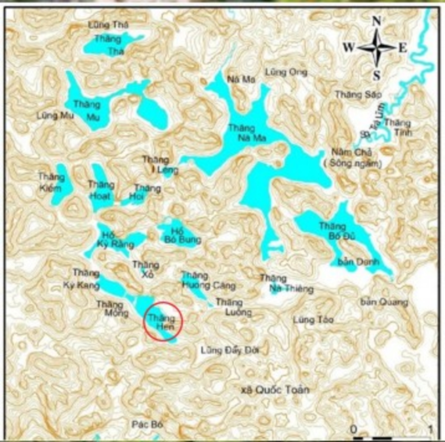
The Thang Hen (bee-tail shape) lake system includes 36 natural lakes connected to each other through under-ground caves and rivers, each of which is several hundred meters apart. All of the lakes are located in a large valley bordered by Quoc Toan Commune (Tra Linh District) and Ngu Lao Commune (Hoa An District). The lakes are named by local language such as Thang Vat, Na Ma, Thang Loong, Thang Hoi, etc; these dated about hundreds of years ago in whichThang Hen is the largest lake with nearly 2,000m long, 500m wide and 40m deep, surrounded by old forests and karren landforms alternating with rugged cliffs. The name “Thang Hen” means “bee-tail” shape, because the helicopter view of the lake looks like the tail of a giant bee.
The system of Thang Hen Lake and underground river caves are developed in limestone of the Bac Son Formation (C-Pbs), at the intersections of several fault systems. The lakes are located on the valley floor surrounded by peaks connected with each other by low saddles, forming a typical karst peak cluster-depression landscape. The peaks, at accordant altitudes, are remnants of a planation surface approximately 650m asl., while the valley floors are at an altitude of 550- 600m. The many waterlines show that the lake water level fluctuates about 20m around the 600m level. Some fossil cave floors are found at altitudes of 600-650m, while active caves are at lower altitudes. According to surveys in 2012 by a group of French-Vietnamese speleologists, the underground cave section that is connected with Thang Hen Lake is 820m long and extends to a depth of 54m below the modern surface.
The karst hydrologic characteristics in Thang Hen lake system are very special in which Thang Hen Lake plays the key role. Observation of the lakes through seasons in a year indicates that the water of all lakes in the the system is dry in the dried season, except Thang Hen lake; in the rainny season the water in all lakes is very muddy, but the water in Thang Hen lake is crystar. In a day, there are 02 tides in Thang Hen lake, etc. The survey of the hydrologic characteristics of Thang Hen lake also showed that:
- All the lakes in the system has at least one funnel for water draining, the lake couldn’t retain water but drained it into the underground rivers.
- In some lakes such as Thang Bo Sung, Thang Bo De, the funnel plays the role as the “draining point” and also the “water supply” source for the lake.
There are 3 possible explaination for this phenomenon:
- In the dry season, the water level is lower than 600m asl. Thang Hen is the largest and deepest lake in the system, and the water in the north-eastern lakes (Thang Tinh, Thang Nam Cha, Thang Na Thieng, etc) is inter-connected and flows into Thang Hen lake through karst funnel systems, underground caves and then becomes dry. The water in Thang Hen lake is connected to the under-ground flows and its level is influenced by the underground/surface flow in the southwestern part.
- Most of the time in the raininy season, the water level is about 600-610m asl. The water volum flown into Thang Hen lake is remarkable while the draining capacity of the Lake is low. In addition, Thang Hen lake plays as the key drainage point (swallow hole), and the water from other lakes flows into Thang Hen and Thang Ky Rang lake then to Thang Mong.
- In case of the water level > 610m asl, the drainage capacity of Thang Hen, Thang Mong is overloaded, once again the water is flown into Thang Hen, but in this case the drainage point is located higher than the bottom of Thang Hen lake.
Visitors to Thang Hen lake system might learn more about other interesting geologies in this area such as fossils (crinoids and fusulinids) in limestones, and facet and evidents of the Cao Bang –Tien Yen deep seated fault. The primative landscapes are evidents of ecological preservation. Thang Hen Lake System is among the treasures of the Cao Bang Geopark and of international significance for its education, sciencetific research, and landscapes.