Some indiginous knowledge in Non nuoc Cao Bang UGGp
- Tuesday - 21/12/2021 17:26
- Close page
Indigenous knowledge or local knowledge is defined as the basis for community-level decision making in areas pertaining to food security, human and animal health, education, natural resource management and other vital economic and social activities. Indigenous knowledge provides strategies to solve issues facing local communities. (World bank)
Unlike academic knowledge that is acquired in professional researching and academic environment (Colleges, Universities), indigenous knowledge is mainly formed through the awareness process and experience from labor and manufacturing activities in the interaction with the natural and social environment; the knowledge is supplimented gradually and passed from generation to generation mostly through oral forms such as folk songs, legends, tales, etc. (Vu Truong Giang, 2009).
Geologic Heritage encompasses the significant geologic features, landforms, and landscapes characteristic of a nation which are preserved for the full range of values that society places on them, including scientific, aesthetic, cultural, ecosystem, educational, recreational, tourism, and other values. Geoheritage sites are conserved so that their lessons and beauty will remain as a legacy for future generations. (The U.S National park service).A Geopark is a unique natural territory with a clearly defined border containing a set of geoheritage of typical geological significance distributed in a certain area harmoniously with the landsacpe as well as containing biodiversity, archeological, historical, siocultural values. Therefore, establishing a Geopark is actually to conserve nature holistically, or in another word, to preserve all heritages including cultural, social, historical, biodiversity and geological heritages.
Developing the Geopark title can be regarded as an effective approach to holistic preservation and promotion of heritage values of an area. In addition, the Global Geopark engages in supporting local communities to conserve their cultural identity by assisting them in realizing the importance of the land they live and be proud of it.
One of criterica for UNESCO gloobal geoparks is local and indigenous knowledge should be included, alongside science, in the planning and management of the area.(IGGPUGG statutes guidelines)
Non nuoc Cao Bang Geopark is recognized by UNESCO in April 2018. Non nuoc Cao Bang Geopark contains unique and typical values related to cultural, historical, biodiversity, and geological heritages. These geological heritages not only have international scientific significance, but are also associated with the intangible cultural values of the local communities. It is the system of legends and tales attached to the history and development of local communities, these values can be considered "soul" of the geological heritages. Especially, many unique geological heritages in the Cao Bang non-country Geopark are explained through legends or tales of local ethnic minorities. It is the combination of scientific knowledge and indigenous knowledge that creates the attractiveness and uniqueness for Non Nuoc Cao Bang Geopark. Therefore, to some extent, conserving geological heritages means preserving the intangible cultural heritage of humanity. This article presents some indigenous knowledge in Non nuoc Cao Bang geopark area.
Ma Phuc pass
Ma Phuc pass is located in Cao Xuyen village, Quoc Toan commune, Quang Hoa district. More than 3.5km long at an altitude of 700m asl, the pass has seven steps and is considered one of the most beautiful passes in Cao Bang. The pass winds between two high limestone mountain ranges and constitutes, at its bottom, an exceptional geosite. Here, in contact with the limestone (white rock) can be seen a blackish green rock with rounded shape - the so-called pillow basalt.
In this area, many submarine volcanoes were active c.260 million years ago. Erupted under sea water the lava cooled down very quickly to result in rounded, stacked pillows (pillow lava). The size and colour of the pillows vary depending on lava composition (basic, intermediate or acidic). More than often one sees blackish green, small-sized (commonly up to one metre in diameter) pillows of basic composition, which rock is, therefore, also called pillow basalt.
Today, a large number of submarine volcanoes are located near areas of tectonic plate movement, known as mid-ocean ridges. Although most submarine volcanoes are located in deep oceans (erupting basic lava), some also exist in shallower water (more acidic in composition), and these can discharge, in addition to lava under water, also ash, bomb and gases etc. into the atmosphere during eruptions. The total number of submarine volcanoes is estimated to be over 1 million.
Beside the exceptional geological interest, Ma Phuc pass is also a place of intangible heritage. According to legend, in the 11th century, a leader of the Nung people named Nung Tri Cao led the local people to fight against the Song army from the north. Once returning from a patrol along the border, at Quoc Toan commune of the present day Quang Hoa district, he faced this high, winding and steep pass, and his horse was crippled and could not move on. The mountain was since named An Lai, literally meaning to stop, and the pass was named Ma Phuc, literally meaning a kneeling horse.
Thang Hen Lake System and Angel mountain eye
The Thang Hen lake system has 36 natural lakes inter-connected through underground river-caves, each of which is several hundred meters apart. All the lakes are located in a large valley bordered by Cao Chuong commune ( Trung Khanh district). The lakes are named in local language such as Than Vat, Thang Na Ma, Thang Hoi, etc. Thang Hen is the largest lake nearly 2,000m long, 500m wide and 40m deep, surrounded by old forests and karren landforms alternating with rugged cliffs. Thang Hen lake was recognized as a national scenic spot in 2001.
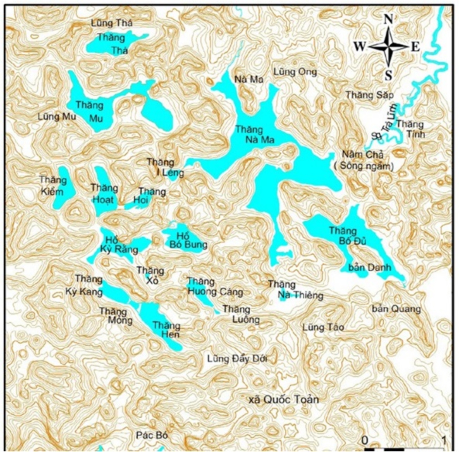
The system of Thang Hen Lake and underground river caves are developed in limestone of the Bac Son Formation (C-Pbs), at the intersections of several NW-SE, SE-WE fault systems. The lakes are located on the valley floor surrounded by peaks connected with each other by low saddles, forming a typical karst peak cluster-depression landscape.
The peaks, at accordant altitudes, are remnants of a planation surface approximately 650m asl., while the valley floors are at an altitude of 550- 600m. The many waterlines show that the lake water level fluctuates about 20m around the 600m level. Some fossil cave floors are found at altitudes of 600-650m, while active caves are at lower altitudes. According to surveys in 2012 by a group of French-Vietnamese speleologists, the underground cave section that is connected with Thang Hen Lake is 820m long and extends to a depth of 54m below the modern surface.
The almost intact landscape shows that the biodiversity is very well-preserved.
To explain the formation of this system of 36 lakes, the local people made up a love story. One upone a time, there was an intelligent handsome guy named Sung. After passing the royal examination to become a mandarin, he was rewarded 7 days to come back his hometown and then went back to the capital. So intelligent and handsome he was that he made many girls in the area fall in love. His family wanted him to get married before coming back to the capital. Among the beautiful girls in the area, Booc has been noticed by his family. A lavish wedding of Sung and Booc was immediately conducted. Fascinated by the beauty of his wife, Sung forgot to return to the capital. It was not until the seventh day that he remembered to be in the capital the next morning. Saying goodbye to his parents and wife, he hurriedly ran back to the capital. However, he was exhausted after running 36 steps, he fell and hit his head on a mountain and died. His 36 steps became 36 large and small lakes with different names in the mountainous region of Trung Khanh district.
Nguom Ngao cave
Located in Gun village, Dam Thuy commune, Trung Khanh district, and commonly described as the most beautiful cave in Vietnam, Nguom Ngao cave (Tiger cave in Tay language) was discovered in 1921 and developed for tourism in 1996. It is recognized as a national scenic spot pursuant to Decision No.95/QD-BVHTTDL of January 24th 1998 of the Ministry of Culture, Sports and Tourism.
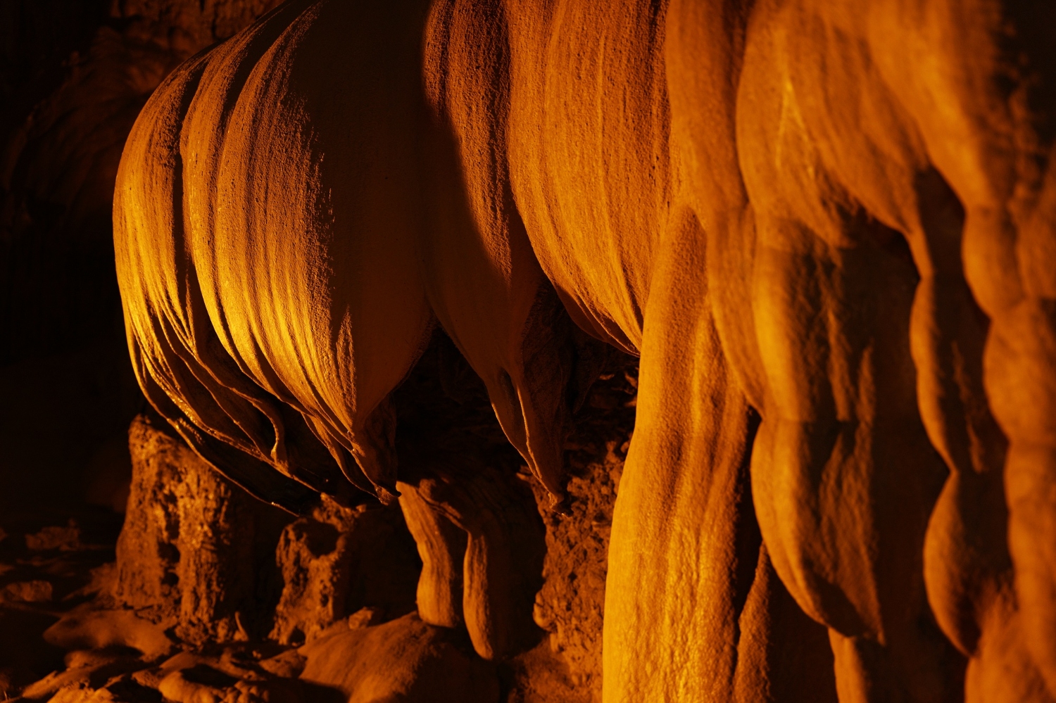
Nguom Ngao cave is developed inside a limestone massif that was formed in an ancient sea about 400 million years ago, containing many Coral and Crinoid fossils. The surrounding karst terrain is peak cluster-depression located on a planation surface at an altitude of 400-600m asl, with many hanging valleys and sinkholes. The cave has several branches trending generally in a NW-SE direction. Within the cave are various chambers, floors, steps and lobbies of many sizes. Speoleothems of various forms are abundant, imitating corals, ships, gold and silver cascades, upturned lotus flowers, individual rock pillars and terraced rice fields. An underground stream with gravel deposits several meters thick flows to the Quay Son river.
Accoring to legend, a lot of ferocious tigers used to live in the cave so the Tay named the cave Nguom Ngao with the meaning “Tiger cave”. However, there is another explaination that the echoing sounds of the underground stream in the cave, like the roar of tiger, give the cave its name.
Nguom Ngao Cave is associated with many legends and tales, including the tale of the upturned lotus flower. When entering Ngom Ngao cave, you will see a stalactite in the shape of an upturned lotus flower in the middle of the cave. According to the tale, long time ago, a Buddhist monk sat in meditation on the lotus longing to become a Buddha but he did not succeed. He was so disappointed that he turned the lotus upside down, and he turned himself into a stone pillar beside the lotus.
Ban Gioc waterfall
Ban Gioc waterfall is approximately 300m wide and 35m high, with three cascades. The waterfall is composed of a main and a subordinate waterfall. The main waterfall, approximately 50m wide, is on the border between China and Vietnam. The subordinate waterfall is situated in Vietnam and is 150m wide, including one cascade approximately 30m high. At this locality, a NE-SW fault cuts through the thinly-bedded limestone and shale of the Ban Cong Formation (D2gvbcg, c.388-383 million years in age, containing Stromatoporoid Amphipora fossils). This has resulted in uplift of the NW side and subsidence of the SE side, thus creating the waterfall.
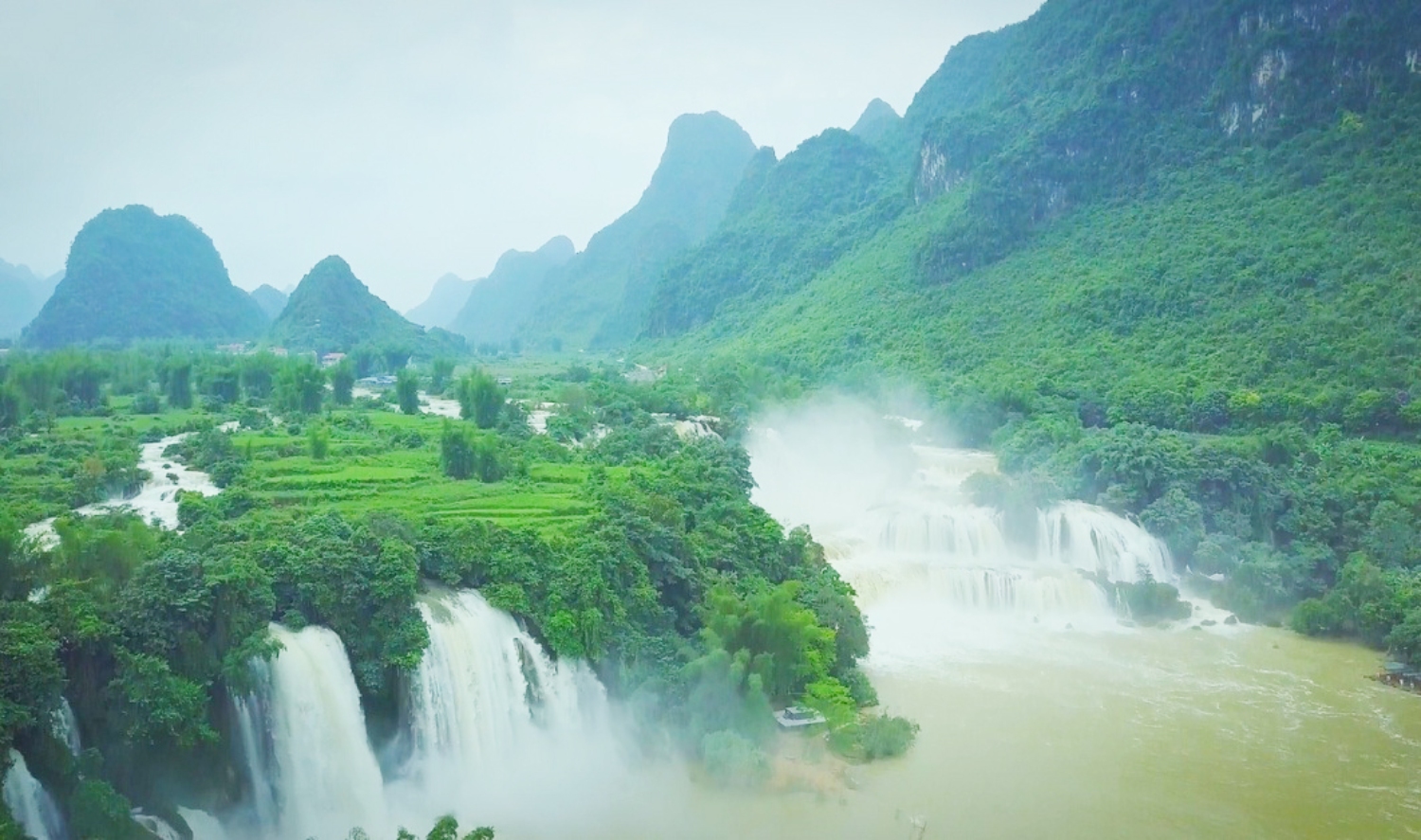
Upstream the waterfall is a mature to old karst landscape with peak clusters-depressions merging with isolated towers on a planation surface at an altitude of 400-600m asl. Downstream the waterfall, the Quay Son River valley extends several km more in a NW-SE direction with fault cliffs and karst fields. Thick forest covers both up and downstream, which, coupled with clean and frothy water all the year round and peaceful and lively human activities, will surely provide visitors with unforgettable experience.
According to legend, there was a beautiful girl chosen to become an imperial consort but she escaped with the man she loved. When they met each other, the girl and her lover died together. Down poured the rain for a week.
Water flooded streams, noone dared to go out because of the torrential rain and loud thunder. Strangely, when the rain stopped, there appeared two large waterfalls spraying white foam beside the village. At the foot of the waterfalls was a gentle jade blue body of water. Since then, local people have called this place Ban Gioc waterfall to commemorate the couple and it is also the pride of the Tay people with the beauty of their girls.